Read Feb. 2, 2016 at Dick Purinton’s home in Byfield, Mass.
On Dec. 11, 1889 in subzero temperatures, John Frank Stevens reached Marias Pass in northwest Montana and discovered the lowest passage for a railroad through the Rockies. Picture him trudging through deep snow after leaving his mule team and exhausted Flathead Indian guide Coonsah behind.
Using 30 year old maps, he found the summit of the pass. Anyone care to guess how he knew he was on the summit when to the naked eye it resembles a canyon plateau more than what we would think of as a mountain summit? He made sure the nearby Flathead River flowed west.
That evening Stevens, a Maine native with no formal technical training, hopped around a campfire to survive the -40 temperatures. The following morning he went back for his exhausted Indian guide and headed back to Fort Assinniboine near Havre where he started this epic trek. It’s little wonder he is described as having “bulldog tenacity of purpose.”
He reported back to railroad magnate James J. Hill that he had found the pass, thus removing the first of two major obstacles standing in the way of the Great Northern railway reaching its western terminus of Seattle. The Marias summit has an elevation of a 5,216 feet.
The Cascades were the next obstacle and Stevens would locate that route as well through a pass that would eventually bear his name and provide the location for successive tunnels, the latter of which is 7.79 miles in length and still in use today. It opened in 1929 and lowered the elevation the initial 1890 crossing from 4,027 feet to 2,894 and eliminated more than 15.5 miles of steep grades and switchbacks that were often slammed by avalanches – sometimes with great loss of life. Indeed on the night of March 1, 1910, the deadliest avalanche in U.S. history slammed into two trapped trains in Wellington, Wash., two miles west of the Stevens Pass summit. Ninety six souls were lost as the trains were hurled like toys 150 feet into a river gorge.
Marias is the lowest of the major railway passes to conquer the Continental Divide. To the southwest, the Northern Pacific Railway now Montana Rail Link tops the divide at Mullan Pass at an elevation of 5,902 feet. The highest U.S. crossing is Tennessee Pass in Colorado at 10,424 feet. Alas, that line closed in 1997 just after the Union Pacific acquired the Denver & Rio Grande and Southern Pacific railroads. I was fortunate enough to see that show when long coal hauls with locomotives in the front middle and end of the train would conquer the 3.5% grade on the western side of the Tennessee Pass tunnel. The higher the pass and steeper the grade, the more tortuous, dangerous, expensive and adrenaline-laced the railroading.
Marias, which would require no long tunnel bores or switchbacks, climbed its eastern approaches at 52.8 feet per mile with a maximum grade of 1.8%. For Hill, discovery of the pass was akin to striking gold.
That’s not to say Marias Pass and the 40 miles on either side of the summit aren’t spectacular and challenging. After all, the rail line forms the southern boundary of Glacier National Park which was largely created by Lewis W. Hill, one of James J. Hill’s 10 children. As second chief executive of the Great Northern, he built resorts in the park fed by a steady supply of passengers from his trains including the Oriental Limited and its successor, the Empire Builder named after his father. Lewis Hill also promoted native American culture and had interests in finance and copper mining.
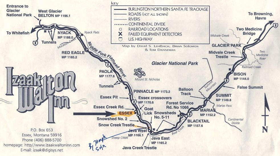
So there Ann and I were standing alone at the desolate summit of Marias Pass in late September under overcast skies with the Burlington Northern Santa Fe (BNSF) tracks running parallel on the northern side of Montana’s scenic route 2. For more than 70 miles between East Glacier and Columbia Falls just south of Whitefish, the so called “Aspen of Montana, ” Route 2 runs alongside the tracks. Our car was the only one in this outsized parking lot and the story boards surrounding a 15 foot statue of a buckskin clad Stevens were faded.
But Stevens is far from faded in my mind for this is hallowed ground for any railfan given these meticulously maintained ribbons of steel that still host 45-50 trains a day. Combine mountain railroading with the blissful rugged splendor that is Glacier and you have Youtube videos that play in your head.
I wasn’t going to write about this topic because I thought a travelogue is a cheap and largely research-less way out of a TNC paper, but upon describing much of this to Richard Welch in a meeting last fall, he said there’s your TNC paper. He was right. It’s better to write about something that evokes passion versus an academic treatise on social media. Thus, you are spared from that for one more year.
Westbound trains drop just over 2,000 feet between the Marias summit and West Glacier, the most popular entrance to the park. Eastbound trains struggle up the grade between Essex, Montana (see map) and the Marias summit, ascending 1,400 feet over just 17.4 miles.
The track bites into the sides of steep canyons and stands out given the thick layers of reddish pink ballast. Watching 100 car tanker trains battle the grade is both meditative and heart pounding. Heavy grains trains drift west and down the grade on their journeys to the ports of Seattle, Portland or Vancouver.
Floods, fires mudslides and avalanches are a constant threat to the railroad not mention every other creature in the region. The 12-mile stretch between Blacktail and Essex is sometimes dubbed “Avalanche Alley” and there are 10 snowsheds to protect the right of way. The region averages 270 inches of snow each winter.
BNSF even has fulltime avalanche forecasters on duty during the winters who decide when to close the line, which is rare. One of them, Ted Steiner, has only recommended closure three times in the past 10 years, once in 2006 and twice in 2014. These manly men climb, snowshoe or ski to the top of the canyons and take core samples of the snow to determine if there’s a weak layer that could trigger a slide.
Walls of snow and ice can bury the tracks, but another problem is when the volume of snow is so great it dams the Flathead River flowing besides the tracks, thus creating flooding conditions.
Newspapers still run stories about the biblical floods in this part of Montana of June 8-9, 1964: one headline read “Torrents of Rain, Miles of Misery” – 31 people perished mostly on the Blackfeet reservation while 2,200 homes were damaged or destroyed. Three dams gave way. The then Great Northern Railway was hit hard and shut down for several weeks, but lesson learned: extensive drainage was installed and has been continually improved.
The 1964 flood was indeed a 100 year flood, but such cataclysmic events seem to occur with much greater frequency. The previous 100 year flood in Montana was only 16 years earlier. The east west line across the central and northern United States is the very definition of cold weather mountain railroading. The engineers, scientists and workers who keep it open take a lot of pride in their jobs as they should.

Ann booked a room for a night at the Izaak Walton Inn in Essex just west of the southern tip of Glacier. The inn was built in 1939 on great northern land and was intended to be an entrance to the park, but WWII intervened and that plan never materialized. Here’s how it was originally described.
“Modern in every detail”, the two and a half story 36 by 114 foot structure boasted 29 rooms, ten bathrooms, a spacious lobby, dining room, kitchen with a two ton cook stove, drying room, store room, and general store.” A private contractor maintained it for the Great Northern workers for its first dozen years.
By today’s standards, this haven or should I say heaven for railfans is a notch above a boarding house, but the front lawn opens up to the BNSF right of way without any annoying fence, threatening trespassing signs or barriers. Railfans can get up close and personal with trains. To boot, the bartender made a heck of martini. Getting’ buzzed and watchin’ trains…
The dimly lit corridor leads to small rooms with circa 1950s fixtures. The attraction for rail fans are passing trains day and night not mention activity in the adjacent small rail yard. There is nothing I treasure more than a good night’s sleep so I could have dispensed with trains waking us up every hour as they passed about 40 yards from our bedroom window.
Why it was named for a 17th century British author and biographer best known for writing “The Compleat Angler” is something of a mystery. This region hosts some great fishing, but the hotel’s “about page” on its web site explains it another way.
“It is not known who named the Izaak Walton Inn but Francis June, a railroad telegraph operator who moved to Essex in 1914, claimed that a man named James Willard Schultz had a lot to do with the naming and renaming of many locations along the Great Northern Railway in Montana. Schultz was an author who lived with and fought beside the fierce Blackfeet Nation in its last glorious days before being confined to a reservation just east of Glacier National Park. He wrote 37 books about his life with the Indians and gained much celebrity from them.”
The highlight and centerpiece of this trip was supposed to be Glacier National Park, but most of the videos playing in my head are from unexpected pleasures along the way. The out of the way 70 mile drive along the Kootenai River where the Libby Dam created a 90 mile lake extending into British Columbia was desolate and breathtaking. Yes, the dams…those incredible dams – the Grand Coulee, Bonneville, the Chief Joseph and many more. You just don’t see things on the same scale in the east.
The irony is the empire builders, money and power emanated out of the east. Stevens and his boss, Elbridge Beckler, were Mainers. Meriwether Lewis and William Clark were Virginia natives. You don’t get more eastern establishment than FDR who created the Bonneville Power Administration which today sells wholesale electricity from 31 dams centered mostly around the massive Columbia River watershed.
Even today, the GOP candidate for governor, Greg Gianforte, who I knew when he was amassing a fortune in technology startups, is a New Jersey native. Most of the thinking that shaped the region’s development was hatched in the east. At Oktoberfest in Whitefish, we met several people from Massachusetts.
Stevens went on to several other railroads and in 1905 was sent by Teddy Roosevelt to be the chief engineer on the Panama Canal where he built out the railroad and excavating infrastructure to finish the job. He resigned in 1907 to return to his primary vocation, railroading. Locks and dams were not his thing and TDR was annoyed that this most capable of men resigned.
Several books have been written about this bulldog of tenacity, considered one of the country’s foremost civil engineers…certainly the most famous with no formal training.
The other unexpected pleasure and fascination on our adventure last Fall was Lolo pass and the ride along the 75 mile Clearwater River and its tributary, the Lochsa. Route 12 between just south of Missoula runs along these rivers of for upward of 200 miles before the Clearwater empties into the Snake River at Lewiston, Idaho. As the largest tributary to the Columbia, the Snake, by the way, is 1,078 miles long and passes through three states. Again, the river speaks to west’s vastness and splendor. The measly Merrimack is a mere 117 miles long.
The coniferous forest along route 12 is spectacular with dense stands of Douglas-fir, several spruce varieties and lodgepole and ponderosa pine. We are cutting across the Bitterroot Range in some of the most seemingly unspoiled terrain in the lower 48. In four hours, we encountered maybe 20 vehicles heading in the opposite direction until we hit a few small hamlets just east of Lewiston.
From the roadway, the magnificent forests appear to be pristine first generation growth, but hike in a mile or two and you will see the ravages of timber clear cutting by the likes of Plum Creek, Weyerhauser and the former Champion Paper company. Weyerhauser announced its acquisition of Plum Creek in November to form the largest holder of timberlands in the nation.
The rich resources prime the Lolo Pass area for the usual pitched battle between conservationists and industry, principally in this case railroads and the timber related concerns.
The Northern Pacific Railway, which cuts east west through central and southern Montana while the Great Northern High Line more or less skirts the Canadian border, acquired land grants around Lolo in the 1870s with idea of building a railroad from Missoula to Lewiston. Alas, the railroad except for a few miles of right of way was never built.
The Northern Pacific holdings around Lolo are called the checkerboard lands given how they are plotted on maps. Plum Creek was formerly Burlington Resources, the heir to Northern Pacific’s land holdings. For the hundreds years previous, the 50 million acres in land grants to the Northern Pacific between Minnesota and Washington state were managed by the railroad’s land department. It was a giveaway of unfathomable proportion, unimaginable riches and questionable legality.
Apparently Exxon and Imperial Oil wanted the narrow and curvy route 12 widened to carry massive loads of tar sand derived petroleum products, but fortunately they dropped those plans in 2012.
Situated on the Montana and Idaho border, Lolo pass is also hallowed ground for this is where Lewis and Clark in the winter of 1805 and 1806 trudged 200 miles west through the Bitterroots on the Lolo Trail led by Old Toby, their Shoshone guide.
From the maps, it appears Lewis and Clark went both east and west through the Bitterroots although they frequently took different routes eastward as they trudged and canoed ultimately back to St. Louis. Said Meriwether Lewis of this part of their Herculean passage through the Bitterroots covered in 6-8 feet of snow.
“The pleasure I now felt in having tryumphed over the Rockey mountains and descending once more to a leave and fertile country where they was rational hope of finding a comfortable subsistence for myself and party can be more readily conceived than expressed, nor was the flattering prospect of the final success of the expedition less pleasing.”
Translation: “Get me outta here” or “Let’s finish this.”
The Lolo trail is also known for the U.S. Army’s unpardonable action against the Nez Perce Indians in 1877. The otherwise distinguished General Oliver O. Howard for whom the one of nation’s first integrated college would be named drove the Nez Perce under Chief Joseph east toward Montana into a smaller reservation in Idaho. The trek was a disaster and many Nez Perce including women and children perished given the suddenness of the order to move in the fall. Again, one of those damned easterners. Oliver Howard, hero of Gettysburg and other civil war battles, West Point commandant and educator was born in Burlington, Vermont. He died there in 1909.
The desperation of the Nez Perce was born out of broken treaties by white men and years of war and skirmishes. They finally surrendered under Chief Joseph to Howard on Oct. 5, 1877. He forced them to move to a 750,000 acre reservation within 30 days. The new reservation was one tenth the size of their lands in eastern Washington and Oregon for which they had a treaty. But gold had been discovered….and you know the rest of the story. Chief Joseph uttered these immortal words in a speech:
“Tell General Howard I know his heart. What he told me before, I have it in my heart. I am tired of fighting. Our chiefs are killed; Looking Glass is dead, Too-hul-hul-sote is dead. The old men are all dead. It is the young men who say yes or no. He who led on the young men is dead. It is cold, and we have no blankets; the little children are freezing to death. My people, some of them, have run away to the hills, and have no blankets, no food. No one knows where they are—perhaps freezing to death. I want to have time to look for my children, to see how many I can find. Maybe I shall find them among the dead. Hear me, my chiefs! I am tired; my heart is sick and sad. From where the sun now stands, I will fight no more forever.
There’s little left of the Lolo Trail today which was used by the Nez Perce for thousands of years to reach their buffalo hunting grounds in Montana and by Lewis and Clark. Clear cutting has seen to that although in the last 40 years, Burlington resources and then Plum Creek have swapped lands with the federal government which has resulted in both conversation and clear cutting.
God, we easterners are a crude, cruel and unruly lot. Gen. Phillip T. Sheridan put it best:
“We took away their country and their means of support, broke up their mode of living, their habits of life, introduced disease and decay among them and it was for this and against this they made war. Could anyone expect less?”
To pass through this stunning region of such beauty, achievement, history, suffering and resources should stir the passions and souls of every American. It did certainly did mine.


2 comments On Marias and Lolo Passes, so much history and splendor
Fascinating trip – wonderfully told story. I had no idea that the pass even existed. Thank you John!
Thank you, Rich.